

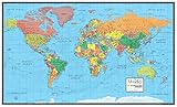
Illustrated Map of the World for Kids (Children's World Map)
Product Description
Illustrated Map of the World for Kids (Children's World Map)
The map offers a wealth of information. It shows more geographical features including: state borders, state capital, major cities, mountain ranges, lakes and major rivers.
More than 300 of illustrations and descriptions on the map show: animals throughout the world and indicates the areas where they live, explorers, historical items, cultural items, ships and sailboats. Legend of icons included.
Laminated with plastic film for extra sturdiness.
Laminated surface is markable and washable with a dry erase marker or water-based pen.
New printing 150 g heavy paper, Corrected and Updated
Size: 27.5x39 inches, Rolled
Technical Specifications
You might also like

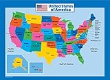
Illustrated map of the US for kids (Laminated Children's Wall Map of the US for Kids) [Map])

Aquarius Smithsonian Our Solar System Poster, 24 by 36-Inch

Teacher Created Resources Solar System Chart, Multi Color (7633)

National Geographic Kids Beginner's World Atlas

Children's Illustrated Atlas
USA Map for Kids - Laminated - United States Wall Chart Map (18 x 24)
30x48 World Wall Map by Smithsonian Journeys - Blue Ocean Edition (30x48 Laminated)

Solar System Educational Teaching Poster Chart Laminated .Perfect for Toddlers and Kids. (Expanded Edition 30” X 15”)

There's a Map on My Lap!: All About Maps (Cat in the Hat's Learning Library)

Daily Schedule Pocket Chart