

Best Maps Ever US National Parks & Federal Lands Poster – 24x36 Wall Art Featuring All Interagency Public Lands: NPS, USFS, BLM, FWS (Tan & Slate Blue)
Product Description
Best Maps Ever US National Parks & Federal Lands Poster – 24x36 Wall Art Featuring All Interagency Public Lands: NPS, USFS, BLM, FWS (Tan & Slate Blue)
- MORE THAN NATIONAL PARKS – ALL U.S. FEDERAL LANDS IN ONE MAP Includes National Parks, Forest Service lands, BLM lands, and Fish & Wildlife areas—over 1300 public land units across the United States. See the full picture of America’s protected lands, not just the parks.
- DESIGNED FOR PLANNING, TRACKING & EXPLORATION Plan road trips, track where you’ve been, and discover new destinations. Ideal for hiking goals, national park trips, and exploring public lands across the country.
- CLEAN, EASY-TO-READ CARTOGRAPHY Clutter-free design with clear labeling and distinct colors for each land type. Quickly understand the map at a glance without overwhelming detail.
- CRISP DETAIL ON HEAVYWEIGHT SATIN PAPER Printed with precision pigment inks for sharp detail and rich color. Smooth satin finish reduces glare and enhances readability.
- LARGE 24x36 FORMAT – READY TO DISPLAY OR FRAME A bold, wall-sized map that fits standard 24x36 frames. Works as both functional wall art and a planning tool.
Technical Specifications
You might also like

John Alcorn: Evolution by Design

Personalized Piano Finish Desk Name Plate - Black, 10.5"

A Crafty Killing (Victoria Square Mystery)

Batman and Robin (2011-2015) Vol. 1: Born To Kill (Batman & Robin Volumes)

Dorman 928-585 Front Suspension Stabilizer Bar Bushing Kit Compatible with Select Dodge/Jeep Models, 5 Pack
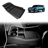
BestEvMod for EV9 Lower Center Console Organizer Tray Interior Accessories Storage Box ABS Material with PVC Trim Compatible with 2024 2025 2026 Kia EV9 Accessories (V2)
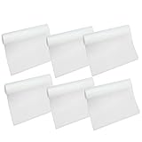
HityTech Refrigerator Liner, 6 Pack Washable Waterproof Mats, 17.75" x 11.75", Clear

Umbra Step Toothbrush Holder, Black