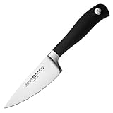
National Geographic: British Columbia, Alberta and The Yukon Territory 1978 - Historic Wall Map Series - 22.75 x 27 inches - Paper Rolled
R 1,793
or 4 x payments of R448.25 with
Availability: Currently in Stock
Delivery: 10-20 working days
This item may be available in a different size, colour, scent, version or platform:
National Geographic: British Columbia, Alberta and The Yukon Territory 1978 - Historic Wall Map Series - 22.75 x 27 inches - Paper Rolled
CLASSY MAP IN OFFICE OR HOME: You can't go wrong with this beautiful production from National Geographic. A guaranteed conversation piece!
A MUST-HAVE FOR COLLECTORS: This map is a beautiful representation of Cold War-era cartography with the distinct colors and cartographic style of the National Geographic maps of today.
QUALITY PRINT: Printed on thick paper suitable for display on your home, school or office wall.
ICONIC CARTOGRAPHY: National Geographic's maps are the standard others are measured against. You can count on this product having the highest quality content and display in the industry.
TRUSTED CONTENT: National Geographic prides itself on the calibre and rigour of its editorial process so that you can count on having accurate information on every map