
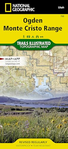
Ogden, Monte Cristo Range Map (National Geographic Trails Illustrated Map, 700)
Product ID: 156695634X
Condition: New
Payflex: Pay in 4 interest-free payments of R217.50. Read the FAQ
R 870
includes Duties & VAT
Delivery: 10-20 working days
Ships from USA warehouse.
Secure Transaction
VISA
Mastercard
payflex
ozow

Product Description
Ogden, Monte Cristo Range Map (National Geographic Trails Illustrated Map, 700)
• Waterproof • Tear-Resistant • Topographic Map
Coverage includes Cache and Wasatch national forests, Wellsville Mountain Wilderness, Ogden, Brigham City, Antelope Island State Park, and Bountiful. Pineview Reservoir with its many recreation points of intertest is also part of the map coverage. The trails in the Wasatch Range from Brigham City in the north to Bountiful in the south are all clearly shown. The recreation opportunities within the Monte Cristo Range are also a primary feature of this map. Includes UTM grids for use with your GPS unit.
Coverage includes Cache and Wasatch national forests, Wellsville Mountain Wilderness, Ogden, Brigham City, Antelope Island State Park, and Bountiful. Pineview Reservoir with its many recreation points of intertest is also part of the map coverage. The trails in the Wasatch Range from Brigham City in the north to Bountiful in the south are all clearly shown. The recreation opportunities within the Monte Cristo Range are also a primary feature of this map. Includes UTM grids for use with your GPS unit.
- Map Scale = 1:75,000
- Sheet Size = 37.75" x 25.5"
- Folded Size = 4.25" x 9.25"
Technical Specifications
Country
USA
Brand
National Geographic
Manufacturer
Natl Geographic Society Maps
Binding
Map
PartNumber
TI00000700
Warranty
Limited Warranty
Color
No Results
Height
8.7
Length
4.3
Weight
0.35053499658
Width
0.6
NumberOfItems
1
You might also like

Logan, Bear River Range (National Geographic Trails Illustrated Map)

Wasatch Front North (National Geographic Trails Illustrated Map)

High Uintas Wilderness Map
Cedar Mountain, Pine Valley Mountain [Dixie National Forest] (National Geographic Trails Illustrated Map)

Hiking Utah's High Uintas: 99 Day And Overnight Hikes (Regional Hiking Series)