
Rand Mcnally
Folded Map: Atlanta Regional Map
Free shipping with 3 or more products in your cart
Payflex: Pay in 4 interest-free payments of R172.00. Read the FAQ
R 688
In stock
Duties, insurance and VAT included
Delivered in 10–20 working days —
Free shipping with 3 or more products in your cart
Secure checkout
Your payment is fully protected
Duties & VAT included
No surprise charges at the door
Tracked delivery
Track your order end to end
Returns support
30-day return window
Description
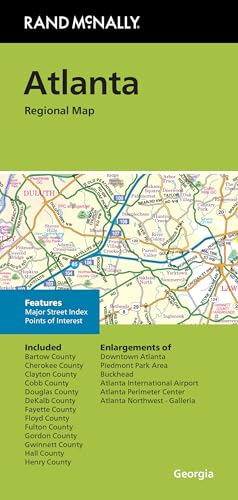
- Regularly updated, full-color maps
- Clearly labeled Interstate, U.S., state, and county highways
- Indications of parks, points of interest, airports, county boundaries, schools, shopping malls, downtown & vicinity maps
- Easy-to-use legend
- Copyright 2024
- Coverage Area Communities Included: Bartow County, Chereokee County, Clayton County, Cobb County, Douglas County, DeKalb County, Fayette County, Floyd County, Fulton County, Gordon County, Gwinett County, Hall County, Henry County
Technical Specifications
Manufacturer
Rand McNally
Model
0528028324
Color
Multicolor
Size
40" x 28"
Shipping & Delivery
Your order is shipped from the USA and delivered to your door in South Africa in 10–20 working days. All items are fully tracked.
Returns & Exchanges
We offer a 30-day return window. If something isn't right, contact our support team and we'll make it right.