
National Geographic Scandinavia Wall Map - Classic (23.5 x 30.25 in) (National Geographic Reference Map)
Product Description
National Geographic Scandinavia Wall Map - Classic (23.5 x 30.25 in) (National Geographic Reference Map)
- Scandinavia Classic: Country and Regions Wall Maps
- Product Type: MAPS
- Brand: NATIONAL GEOGRAPHIC
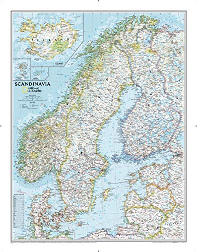
National Geographic's wall map of Scandinavia is one of the largest and most detailed maps of the region. The signature Classic style design uses a bright, easy-to-read color palette. This map features thousands of place names, accurate political boundaries, national parks, and major infrastructure networks such as roads, superhighways, airports, canals, ferry routes, and high-speed and passenger railroads. The region's diverse terrain is detailed through accurate shaded relief, coastal bathymetry, and symbolism for water features and other land forms. Elevations of major peaks and depth soundings are expressed in meters. Inset maps provide detail of Iceland, the Faroe Islands, and Jan Mayen. In addition to Norway, Sweden, and Finland, coverage includes Denmark, Lithuania, Latvia, Estonia, and Kaliningrad Oblast.
The map is packaged in a two inch diamater clear plastic tube. The tube has a decorative label showing a thumbnail of the map with dimensions and other pertinent information.
- Map Scale = 1:2,765,000
- Sheet Size = 23.5" x 30.25"
Technical Specifications
You might also like

Britain and Ireland Wall Map (tubed) British Isles

Southern Sweden and Norway (National Geographic Adventure Map)

The Rough Guide to Norway (Travel Guide) (Rough Guides)

DK Eyewitness Travel Guide Norway

Lonely Planet Norway (Travel Guide)

Moon Norway (Travel Guide)

Michelin Norway Map 752 (Maps/Country (Michelin))

Anley Fly Breeze 3x5 Foot Sweden Flag - Vivid Color and UV Fade Resistant - Canvas Header and Double Stitched - Swedish Banner Flags Polyester with Brass Grommets 3 X 5 Ft

National Geographic: Germany Classic Wall Map (23.5 x 30.25 inches) (National Geographic Reference Map)

National Geographic: England and Wales Classic Wall Map (30 x 36 inches) (National Geographic Reference Map)