


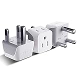
South Africa, Botswana Travel Adapter Plug by Ceptics With Dual USB + USA Input - Type M - Ultra Compact - Safe Grounded Perfect for Cell Phones, Laptops, Camera Chargers and More (CTU-10L)
Appliances
Arts, Crafts & Sewing
Automotive
Baby
Beauty
Books
CDs & Vinyl
Collectibles & Fine Arts
Cell Phones & Accessories
Clothing, Shoes & Jewellery
Computers
Electronics
Health & Personal Care
Home & Kitchen
Industrial & Scientific
Luggage & Travel Gear
Musical Instruments
Office Products
Patio, Lawn & Garden
Pet Supplies
Software
Sports & Outdoors
Tools & Home Improvement
Toys
Video Games


![Cape Town and Peninsula [South Africa] (National Geographic Adventure Map)](https://m.media-amazon.com/images/I/51Rrs7+WktL._SL160_.jpg)


