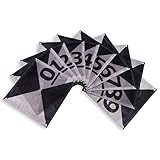
DronePoints - Black Aerial Target Kit (Standard) - 12" Diameter - 20 Pack - Ground Control Target & Stencil System for Drone Mapping & Survey
48"x48" Drone Ground Control Point GCP 6 Pack - Black/White Markers UAV Aerial Target for Mapping & Surveying
Sky High Bull's-Eye (24"x24") Drone Ground Control Point GCP with Adhesive Backing for Roadways & Pavement - Black/White Aerial Target for Mapping/Surveying (6 Pack) | Pix4D & DroneDeploy Compatible
Sky High Bull's-Eye Weighted Ground Control Points (GCPs)/Aerial Targets for Aerial Mapping & Surveying (6 Pack) with Center Hole (24"x24")
Sky High Bull's-Eye Disposable Ground Control Points (GCPs)/Aerial Targets for Aerial Mapping & Surveying (100 Pack) with Center Hole (18” x 18”) - Bonus Bag & 500 Stakes Included
Sky High Bull's-Eye 24” LiDAR Ground Control Point GCP - UAV Aerial Target for LiDAR Mapping & Surveying (6 Pack) Retro-Reflective Black Hexagon with Center Eyelet for Aerial Mapping & Photogrammetry
Sky High Bull's-Eye Drone Ground Control Point GCP - UAV Aerial Target for Mapping & Surveying (10 Pack) | Center Eyelets Numbered 0-9 (Black/Grey Markers) | Pix4D & DroneDeploy Compatible
Sky High Bull's-Eye (48"x48") Drone Ground Control Point GCP - UAV Aerial Target for Mapping & Surveying (6 Pack) | Center Passthrough (Black/White Markers) | Pix4D & DroneDeploy Compatible